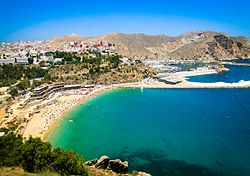
Al Hoceima is a city on the northern edge of the Rif Mountains and on the Mediterranean coast. It's a known tourist destination despite its small size. It is characterised by its shining sandy beaches like Cala Iris, Bades, Torres, Quemado, and Tala Youssef, and its mountainous rocky areas. It has a population of about 57,000 people.

Understand
[edit]The population in this area belongs predominantly to the ethnic group of Berbers.
The region was part of Spanish Morocco from 1912 to 1956. The native Berbers declared their independence in 1920 and founded the Rif Republic. Their capital was the small town of Ajdir, today a suburb of Al Hoceima. However, the Spaniards did not recognise the new state and fought it violently with the help of French. In this war Spain used mustard gas bombs on a massive scale, contrary to international law. The effects are still being felt today: the area has far more cases of lung cancer than the national average. In 1926 Villa Sanjurjo was founded as a Spanish outpost, from which today's Al Hoceima has developed.
After Morocco gained its independence in 1955, Al Hoceima quickly developed and the Moroccan government changed its name from the Spanish Villa Alhucemas to Al Hoceima.
The three Alhucemas Islands, which lie just a few hundred meters off the coast of Al Hoceima, still belong to Spain today. There is a Spanish military base there, but no permanent population.
Get in
[edit]By plane
[edit]
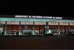
Royal Air Maroc operates several domestic flights from Casablanca, Tangier and Tetouan. While Transavia operates the only international route from Rotterdam/The Hague.
1 Cherif Al Idrissi Airport (9 km SE of the city).
By bus
[edit]CTM[dead link] coaches run twice daily from Casablanca (over 11 hours, 200 dirham) via Rabat (just under 10 hours, 170 dirham), Meknes, Fes (just under 6 hours, 110 dirham) and Taza.
Get around
[edit]See
[edit]
Nearby
[edit]
- 1 Islas Alhucemas – an island administered by Spain.
- 2 Peñón de Vélez de la Gomera – a peninsula only populated by Spanish military
- 1 Al Hoceima National Park. The park is characterised by high limestone cliffs and a wild rocky coast.

