Izberbash is a small city of some 60,000 people (2020) on the coast of the Caspian Sea in Dagestan between Makhachkala and Derbent. It is known as a city of oil workers, but it is developing into a resort and recreation center on the shores of the Caspian Sea.
Understand
[edit]Climate
[edit]| Izberbash | ||||||||||||||||||||||||||||||||||||||||||||||||||||||||||||
|---|---|---|---|---|---|---|---|---|---|---|---|---|---|---|---|---|---|---|---|---|---|---|---|---|---|---|---|---|---|---|---|---|---|---|---|---|---|---|---|---|---|---|---|---|---|---|---|---|---|---|---|---|---|---|---|---|---|---|---|---|
| Climate chart (explanation) | ||||||||||||||||||||||||||||||||||||||||||||||||||||||||||||
| ||||||||||||||||||||||||||||||||||||||||||||||||||||||||||||
| ||||||||||||||||||||||||||||||||||||||||||||||||||||||||||||
The climate is strongly influenced by the Caspian Sea, due to which autumn is long and warm, and spring comes with a delay. Winters are mild, snow lasts only two weeks a year, the coldest month is usually February. The sea does not freeze (the average water surface temperature in February here is +3.5 °C), however, ice floes from the northern Caspian are driven to the shores of the wind, especially numerous in severe winters. Summer is long and hot.
Get in
[edit]It is 56 km (35 mi) southeast of Makhachkala.
There are two marshrutkas daily from Makhachala and Derbent.
Get around
[edit]See
[edit]
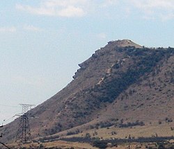
- 1 Mount Pushkin-Tau (Mount Izerbash). Its slope resembles the profile of A.S. Pushkin.
Do
[edit]- Izberbash's main beach is at the end of Ushakova Street. It is quite long (about 3 km long) and rather wide (200 m wide). Local sand has a fine-grained structure, in places mixed with shells. Natural rock ridges function as natural breakwaters and protect beaches from surging waves quite well. There are usually no storms and hurricanes in the Izberbash area. The beach has changing cabins, sun awnings, band enches. There are also thermal showers on the beach. The sand is regularly sifted with a sand cleaning harvester. Rescue posts are also equipped. There are two paved parking lots near the beach for easy access to its territory.
Buy
[edit]Eat
[edit]Drink
[edit]Sleep
[edit]Stay safe
[edit]Go next
[edit]

