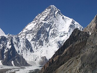
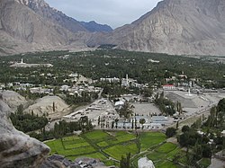
K2 base camp trek is a multi-day hike generally based from Skardu, Pakistan. It takes about 10 to 16 days and involves a distance of about 180 km return. The hike occurs within the Central Karakoram National Park (CKNP).
K2, at 8,611 m (28,251 ft) above sea level, is the second-highest mountain on Earth, only about 250 m less than Mount Everest. Mountaineers consider it a more difficult and dangerous climb than Everest, partly because it is considerably farther north so poor weather is more common.
For general information on the mountains of the region, see Himalayas. K2 is in the Karakoram range, not in the Himalaya proper.
Understand
[edit]When to go
[edit]
The best time to hike is July and August, though the trail can be done as early as June to as late as September; otherwise winter conditions will be present. The Mountain Rescue Support Team is only available for Gondogoro La until around August 27th.
Permits
[edit]The hike cannot be done independently as the government requires foreigners to be accompanied by an approved guide.
A special trekking visa is required to do the hike. Acquiring this visa takes about 4 weeks, requires a letter from one of 216 approved trekking companies, and the process can be started 6 months before your arrival in Pakistan. Visas are then good for 3 months from your arrival. To enter the CKNP a fee of US$300 is required as of 2024; this is paid on your behalf by the trekking tour company.
Whether a person uses porters is an individual choice. However; the required guide, will generally require at least one porter. Most groups thus have 2 to 10 local staff per foreign trekker (staff may include guides, porters, cooks, and horse people). Many groups also travel with a team of horses.
To actually attempt climbing K2, fees are higher, up to $5000 per climber depending on season. You must also pay for insurance for your porters.
Sleeping
[edit]After leaving Skardu, camping becomes the primary or only option; with only small very basic hostels at Askole and Hushe.
Gear
[edit]With respect to glacier gear, if one is to cross Gondogoro La, crampons, climbing harness, and a carbineer are generally recommended. There are fixed ropes for certain sections during July and August and thus bringing ones own ropes is only required outside this season. In 2023 the fixed ropes were removed August 28th.
As of 2023 cost for using the ropes is 28,000 Rs for up to 2 people, 38,000 for 3 to 4 people. Over 4 people each additional person is 9,000 Rs.
Cost
[edit]Doing this trek is fairly expensive. Getting the appropriate visa can require paying around $900 US for the letter of invitation from a government approved company (this price includes the $150 CKNP fee). Next you will need to hire a guide, a porter for the guide, food for the two of them, and pay for jeep transport to and from the start which costs about $1,100. The jeep transport itself is about 25,000 rupees (just under $100) while porter wages are about US$144 for the trip.
For two hikers travelling with minimal support and with all their own gear and food the cost runs around $3,000 making this one of the more expensive countries in the world in which to trek.
Tourist information
[edit]Get in
[edit]There are generally daily direct flights from Islamabad to Skardu with Pakistan International Airlines that take about an hour of flight time. There are also flight to Skardu from Karachi. Flights, however, only operate when the weather is favorable.
Skardu is on the Karakoram Highway so it is also possible to reach it by car or bus. The bus from Islamabad can take up to 36 hours. A stopover in Gilgit breaks up that journey and allows for acclimatisation to the altitude; Gilgit is around 1500 m, Skardu over 2000, and the actual trek higher. Flying in to Gilgit then taking a bus to Skardu is also an alternative.
Itinerary
[edit]The initial part of the trip is generally by Jeep from 1MISSING WIKILINK Skardu at 2,226m to the village of 2 Askole. This takes about 6 hours; though is variable. It is now almost possible to continue driving another 2 to 3 hours until Jhola and this has become the new starting point by 2024 or 2025 as a new bridge is finished.
Camp sites occur at:
- Askole (3,050m)
- Korophong: No toilets. Limited facilities.
- 1 Jhola (3,200m) Also known as Jola, facilities include toilets and water for washing
- Bardumal
- Paiju (3,450m) facilities include toilets, water for washing, and garbage cans. A coke goes for the exceedingly expensive price of 1,500 rupees (maybe less with bargaining)
- Trango BC
- Khoburtse few facilities
- 2 Urdukas (3,990m) facilities include toilets, water for washing, and garbage cans
- Goro 1
- Gore 2 (4,380m)
- 3 Concordia (4,620m) is the confluence of the Baltoro and Godwin-Austen glaciers. Toilets present.
- Broad peak basecamp (4800m). Very few facilities.
- 4 K2 base camp (5,000m). Very few facilities.
After this are high camps used by those attempting to summit 1MISSING WIKILINK K2:
- Advanced base camp (5,250m)
- Camp 1 (6,000m)
- Camp 2 (6,650m)
- Camp 3 (7,300m)
- Camp 4
On the return from base camp trekkers may choose to go over 2 Gondogoro Pass at 5585m and onto 3 Hushe or return they way they came. Going over the pass requires the use of crampons, fixed ropes, and an ice axe. A jeep ride from Hushe back to Skardu may than be taken.
From Concordia camping spots include:
- Ali camp (5,000m)
- Khuspang
- Shaisho
- Hushe (3,048m)
The drive from Hushe back to Skardu takes about 6 hours.
-
Skardu
-
Shigar valley
-
Askole
-
Baltoro glacier from Urdukas campsite
-
Concordia circus
-
Broad peak base camp
-
K2 base camp
Map
[edit]A map of the route with campsites marked.
Stay safe
[edit]It is estimated that around 25% of foreigners need rescue either by horse or by helicopter due to sickness or injury. Rescue by horse costs about $300 to 600 US depending on your bargaining skills. Helicopter rescue is via the Pakistani military, the only option, at a cost of $13,000 to 15,000. It is often a good idea to include pack horses when planning your trip so that you are covered if something goes wrong.
The greatest risk is probably infectious diarrhea, with most foreigners getting at least somewhat sick. Sanitation is basically non-existent on much of the route. While toilets are available at certain camps, open defecation is still very common. On the glacier water is collected from the contaminated run off and when insufficiently boiled causes sickness in those without tolerance. Typical symptoms include nausea, diarrhea, and weakness which may last a few days. The vaccine Dukoral may help prevent some cases. After onset, the antibiotic azithromycin 500 mg once per day until better or at most 3 days may help. Antibiotics can be easily and inexpensively purchased in Skardu. Remember to bring sufficient baby wipes, much stronger than toilet paper, just in case.
Altitude sickness is also a risk; Askole is above 3,000 m, base camp is about 5,000 m and Gondogoro Pass is around 5,500 m. Allow time in your schedule to acclimatize with the goal of at most 400 m elevation gain per day.
Even the trek to the base camp requires good health, good boots and clothing, and considerable effort. The trail is rough, narrow, and unstable in places. There are also sections with significant overhead hazards such that crossing during heavy rains may be unsafe. Going over Gondogoro Pass requires greater efforts and equipment, as mentioned above. Both require decent weather and should not be attempted in winter.
Actually trying to climb K2 is extremely difficult and dangerous, more so than Everest. Only expert mountaineers with good guides and equipment should even consider it. Wikipedia says that, as of 2021, 377 people had reached the summit and 91 had died attempting it.


