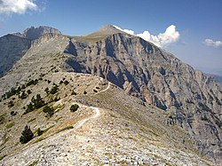
Olympos National Park, in the Macedonian-Thessalian border in northern Greece, is home to Mount Olympus, the country's highest mountain (2,918 m).
Understand
[edit]The major entrance to the park is the village of 1 Litochoro.
The village of 2 Dion, Pieria is the starting point of a forested road ending at Koromilia Dion Refuge.
3 Palaios Panteleimonas is a traditional village in the lower Olympus, in fact a completely separate and different mountain, though very close to Mount Olympus. The village sits at an altitude of 700 m, with a magnificent view over the coast.
Visitor information
[edit]- Olympos National Park[dead link] website
Get in
[edit]
KTEL Intercity Buses operate (10 daily - €9.30) from Thessaloniki to Litochoro with an intermediate stop at Katerini. The bus schedule can be found at the website of the Thessaloniki station.
The main line of the Greek railway system that connects Athens with Thessaloniki passes through Katerini. Even the fast Intercity trains make a stop at Katerini railway station. You can catch a bus to Litochoro from the nearby bus station. Keep in mind that bus service[dead link] does not operate on Sunday or holidays.
Olympus' massif is found about in the middle of Continental Greece and is easy to approach from the national railway network on the Athens-Thessaloniki line and the secondary roads that connect towns and villages around the mountain, with the principal base for excursions being the town of Litochoro, where there are many hotels and taverns. In addition, on Pieria's coastal zone there are many camp sites and lodgings. The nearest international airport is that of Thessaloniki, and railway stations are those of Litochoro, Katerini and Leptokarya. There is frequent service by KTEL buses and a taxi stand is in Litochoro's central square.
- By air: Makedonia Airport in Thessaloniki, 80 km away from Katerini and 150 km from Elassona.
- By train: Athens-Leptokarya (regular line), Athens-Katerini (Intercity) and Thessaloniki-Litochoro (Suburban and regular line).
- By bus: Athens-Katerini (437 km), Thessaloniki-Katerini (68 km), Katerini-Litochoro (25 km), Athens-Larissa (354 km), Larissa-Elassona, Elassona-Kokkinopilos (22 km), Elassona-Karya (36 km).
- By car:
- To Litochoro via Highway No. 1 (E75) (412 km away from Athens, 93 km from Thessaloniki).
- To Elassona via National Roads Athens-Larissa (354 km) and Larissa-Elassona (38 km).
- To Karya via road Larissa-Rodia-Sykaminea-Karya (48 km).
- To Karya via road Leptokarya-Karya (24 km), or Neos Panteleimonas-Kallipefki-Karya (37 km).
- To Kokkinopilos from Elassona via road Katerini-Foteina-Elassona (46 km) or via forest road Foteina-Petra-Kokkinopilos.

Get around
[edit]By foot or by donkey.
See
[edit]Olympus' highest peak is 1 Mýtikas at 2918 meters (9570 feet).
- 2 Agios Dionysios Monastery. In the Enipeas river gorge.
- 3 Ourlias Waterfalls.
- 4 Olympos National Park Information Center, Litochoro.
Itineraries
[edit]- The most common itinerary is the international hiking path E4: Litochoro, Prionia (1,100 m), Spileos Agapitos (2,100 m), Skala, Mytikas (2,918 m).
- The path "Barba - Kolokythia - Petrostrounga (1,940 m) Skourta (2,485 m) - Refuge Giosos Apostolidis - Mytikas" is less frequented but equally scenic.
- The Greek hiking path O2, ascending from Karya to the summits.
- The most easy hiking path starts from the Christakis refuge and leads within 90 minutes to the Skolio summit (2,912 m) and from there further to the highest summits, the Mytikas (2918 m) and the Stefani (2902 m).
Do
[edit]Eat
[edit]Drink
[edit]Sleep
[edit]
There are 9 refuges where you can stay overnight for €15 per person per night. You can also camp.
- 1 Christos Kakkalos Refuge, 2648m (Refuge G on map), ☏ +30 693 7361689 (Mobile).
- 2 Spilios Agapitos Refuge (Refuge A on map), ☏ +30 23520 81800, +30 23520 81329.
- 3 Giosos Apostolidis Refuge, ☏ +30 2310 224710. Operates from June 15 to October 7. Sleeps 101 people and has an organized kitchen
- 4 Dimitrios Boundolas Refuge (Stavros Refuge) (Refuge D on map).
- 5 Koromilia Dion Refuge.
- 6 Petrostrouga Refuge, ☏ +30 23520 83000. Built at an altitude of 2000 m, the refuge sleeps 80 people.
- 7 Vrysopoules Refuge (KEOAX Refuge) (Refuge B on map). On the south side of Mount Olympus at an altitude of 1800 m above Mavratza Gorge. Due to its location on military owned land it is necessary to contact the military base by calling +30 24930 62163.
Stay safe
[edit]Go next
[edit]


