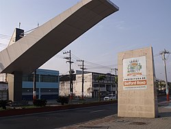
Belford Roxo is a city of Baixada Fluminense, in Grande Rio. It is a part of the metropolitan region of the city of Rio de Janeiro.
Understand
[edit]
Belford Roxo is the third most populous of the 13 municipalities of the region of Baixada Fluminense, following only Nova Iguaçu and Duque de Caxias. It has also one of the highest demographic densities in the state of Rio de Janeiro. The current municipality of Belford Roxo was a district of Nova Iguaçu until 1990, when it was emancipated.
Get in
[edit]The municipality is served by suburban trains through the Belford Roxo railway line, which starts in the Central do Brasil station, in downtown Rio de Janeiro, goes through the capital's North Zone and the municipality of São João de Meriti, and enters thereafter the municipality of Belford Roxo, ending in the Belford Roxo train station, located in the city center. In the surroundings of the last station of this railway line, urban bus lines are available to several neighborhoods of Belford Roxo and other locations in Greater Rio in general.

From the Central Zone of Rio de Janeiro, urban bus, van and train lines depart towards Belford Roxo. Most bus lines to Belford Roxo depart from Terminal Américo Fontenelle, in the neighborhood of Gamboa, in the downtown area of Rio de Janeiro, and the trains to the municipality depart from Central do Brasil station. The vans to Belford Roxo also depart from the surrounding area of Central do Brasil.
The main road access to Belford Roxo for those coming from downtown Rio de Janeiro is the BR-116 highway (Via Dutra).
Get around
[edit]See
[edit]- Praça de Areia Branca (Areia Branca Square). The main square of the neighborhood of Areia Branca.
- Igreja de Nossa Senhora da Conceição (Church of Nossa Senhora da Conceição). A church in the Belford Roxo city center.
- Igreja de São Simão (Church of São Simão). A church in the neighborhood of Lote XV, close to the limit with Duque de Caxias.
- Parque Industrial da Bayer (Bayer Industrial Park). An important industrial park between the Belford Roxo city center and the neighborhood of Bom Pastor.
- Estação ferroviária de Belford Roxo e a antiga Estrada de Ferro Rio d'Ouro (Belford Roxo train station and the old Rio d'Ouro Railway). The Belford Roxo station is the last train station in the railway stretch between Pavuna, in the North Zone of Rio de Janeiro, and the Belford Roxo city center, a stretch of the 19th-century Rio d'Ouro Railway which is still used by commuter trains. The Rio d'Ouro Railway was built to assist in the construction of water mains for the city of Rio de Janeiro from springs of Serra do Tinguá, a section of the longer mountain range known as Serra do Mar. The building of this railway was concluded on 1882.
- Área de Proteção Ambiental do Alto Iguaçu (APA Alto Iguaçu - Alto Iguaçu Environmental Protection Area). Environmental Protection Area in the north of the municipality.
Do
[edit]- Vale do Ipê Country Club - Estrada Manoel de Sá, 118 - Vale do Ipê. - The country club offers 50 rooms equipped with flat-screen TV's with satellite channels, multi-channel television and balconies for a pleasant stay in Greater Rio. In the club, it is possible to go hiking, trekking, play games, swimming in a large water park, and play various sports.
Buy
[edit]Eat
[edit]- Pizzaria Tarantela - Avenida Joaquim da Costa Lima, 2480 - Vilar Novo, Graças.
Drink
[edit]Sleep
[edit]- Gran Hotel Souto - Rua Vinte e Oito de Setembro, 125 - Guaraciaba, Centro.
