Kettle Falls is a small city in northeast Washington State.
Understand
[edit]- 1 Kettle Falls Information Center, 425 W 3rd Ave, ☏ +1 509-738-2300.
Get in
[edit]Kettle Falls is at the junctions of US Highway 395 (US-395), State Route 20 (WA-20), and State Route 25 (WA-25), about 80 mi (130 km) northwest of Spokane and 41 mi (66 km) south of the Canadian border.
Get around
[edit]See
[edit]- 1 China Bend Winery, 3751 Vineyard Way, ☏ +1 509-732-6123.
- 2 Kettle Falls Historical Centre, 1188 St. Paul Mission Rd, ☏ +1 509-738-6964. An interpretive center and other exhibits allow you to learn about 9,000 years of human history. Exhibits range from the Native American fishermen to white settlers.

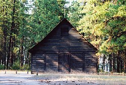
- 3 St. Paul's Mission. This 1846 church is one of the oldest in Washington. A trail with exhibits is nearby.
Do
[edit]- The Lake Roosevelt National Recreation Area, a 130-mile-long (210 km) recreation area along the reservoir created by the Grand Coulee Dam. Kettle Falls is at the north end of the lake; the actual Kettle Falls were submerged with the creation of Lake Roosevelt.
- 1 Bull Hill Ranch, 3738 Bull Hill Rd, ☏ +1 877-285-5445. Enjoy the scenic horseback riding trails of the area
Buy
[edit]- 1 Columbia View Orchard, 1280 Peachcrest Rd, ☏ +1 509-738-2309.
- 2 The Old Apple Warehouse, 130 East 3rd Ave, ☏ +1 509-738-4848. An Antique and Collectibles shop, the oldest and most unique sight in Kettle Falls.
- 3 Sherman Creek Orchard, 32 Apple Tree Dr, ☏ +1 509-404-1027. Local produce
Eat
[edit]Drink
[edit]Sleep
[edit]- 1 Kettle Falls Inn Hotel, 205 East 3rd Avenue, ☏ +1-509-738-6514. Hotel/Motel.
- 2 Columbia Point Resort, 978 Hwy 395 North, ☏ +1-509-690-4208. Hotel/Motel/RV Park.
- 3 Lake Roosevelt Vacations, Inc., 1390 Williams St, toll-free: +1-800-635-7585. Houseboat rentals.
- 4 Kettle Falls Campground, 1368 Kettle Park Road (5 miles southwest of Kettle Falls). Campground.
- 5 North Lake RV Park & Campground, 20 Roosevelt Road (9 miles northeast of Kettle Falls on US 395.), ☏ +1-509-738-2593. Cabins/RV Park/Campground.
- 6 Riverwood Bed & Breakfast, 7 Riverwood Circle E (4 miles west of Kettle Falls.), ☏ +1-509-850-0873. Bed & Breakfast.
- 7 Bull Hill Guest Ranch, 3738 Bull Hill Road (About 30 miles north of Kettle Falls.), toll-free: +1-877-285-5445. Guest Ranch.
Connect
[edit]- 2 Kettle Falls Public Library, 615 Meyers St, ☏ +1 509-738-6817.
Go next
[edit]- Colville − 9 mi (14 km) east of Kettle Falls along US 395 / WA 20.
| Routes through Kettle Falls |
| Grand Forks via |
N |
→ Colville → Spokane |
| Omak ← Republic ← | W |
→ Colville → Newport |
| Castlegar ← Rossland ← becomes |
N |
→ Davenport → END |

