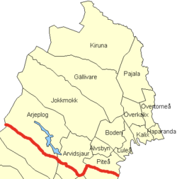
Norrbotten County, Norrbottens län, is the northernmost part of Norrland, Sweden.
Bordering to Norway and Finland it covers 100,000 square kilometres (nearly a quarter of Sweden's total area and larger than countries such as Hungary and Portugal), from the tall mountains in the west to the coast and archipelagoes in the east. It includes the province of Norrbotten and the northern part of the province of Lappland. Much of Norrbotten County is within the Arctic Circle, meaning that Midnight Sun and Arctic Night occur.

The county has a mere 250,000 inhabitants (2.5% of the national population), most of them in Luleå, Piteå, Boden, and Kiruna.
Municipalities
[edit]
Norrbotten proper
[edit]- 1 Luleå, the county seat and largest city
- 2 Piteå
- 3 Älvsbyn
- 4 Boden, the Swedish Army's stronghold against invasions from the east
- 5 Kalix
- 6 Överkalix
Tornedalen
[edit]Tornedalen, the valley of Torne River, is home to a Finno-Ugric community with Meänkieli as their mother tongue.
Northern Lappland
[edit]- 10 Kiruna, the country's largest by area, contains settlements such as Jukkasjärvi, Abisko, Karesuando and Riksgränsen, as well as Kiruna itself.
- 11 Gällivare, a mining town
- 12 Jäkkvik, a common stop for hikers and snowmobilers
- 13 Jokkmokk, the municipality including Kvikkjokk, 14 Murjek and 15 Porjus
- 16 Arjeplog
- 17 Arvidsjaur
Other destinations
[edit]- 1 Abisko, a national park
- 2 Jukkasjärvi, with the Ice Hotel
- 3 Kebnekaise and Nikkaluokta, Sweden's tallest mountain
- 4 Kvikkjokk, gateway to Laponia
- 5 Laponia, four national parks, and the largest wilderness in Europe
- 6 Pieljekaise National Park protects an area of pristine mountain birch forest and serves as a transition zone between forested lowlands and alpine highlands
- 7 Riksgränsen, a ski resort
- 8 Ritsem, a remote hub for hiking trails
Understand
[edit]Lapland is the homeland of the Sami: Sápmi. While Swedish settlers arrived to the coast in the 14th century, and Sweden claimed the land in the 16th century, the communities remained isolated, speaking either Sami, Meänkieli (close to Finnish), or bondska, a Nordic dialect group very different from standard Swedish.
The demand for iron and wood induced a wave of colonization in the late 19th century with enormous investment in railways, mines and hydroelectric plants, which are today indispensable to the Swedish economy. In the late 20th century, the industries were automated, and the countryside was again depopulated, though tourism and space science have emerged as new businesses – and many of the Sami are still there.
Seasonal variations of temperature and daylight are dramatic, and the Midnight Sun can be seen in much of the country. See winter in the Nordic countries.
Talk
[edit]Though Swedish is the everyday language, and English is well understood, the northern edge of Sweden is linguistically diverse. The Sami languages, as well as the Meänkieli at the Torne river, are Finno-Ugric; similar to the Finnish language, the latter mutually intelligible. Some of the most archaic Swedish dialects, collectively described as bondska, have survived in towns such as Överkalix.
Get in
[edit]Resrobot is a search engine for all public transport in Sweden.
By plane
[edit]Domestic airports are located at Arvidsjaur, Luleå, Gällivare, Kiruna, and Pajala. Most planes arrive from Stockholm-Arlanda airport (ARN IATA).
By train
[edit]- SJ has sleeper trains from Stockholm and Gothenburg to Luleå and Kiruna.
- The Inlandsbanan railway leads through the more sparsely populated inland via Östersund and Arvidsjaur to Gällivare. This is more or less a tourist line,
- In Finland there are overnight trains to Kolari via Tornio (sparsely off season), and via Kemi to Rovaniemi. Some of them take cars to Oulu and Kolari. Continue by car via Haparanda or Pajala, or by coach via Haparanda.
- From Norway there is the Malmbanan railway Narvik–Luleå.
By bus
[edit]- Matkahuolto has schedules for buses coming from Finland (f.ex. from Oulu and Rovaniemi) to Haparanda/Tornio travel centre.
- Tapanis Buss has a route between Tornio, Finland and Stockholm serving coastal region along road E4
By car
[edit]- From south Sweden to Kiruna or Gällivare: E4 and E10. For Pajala use road 392.
- From south Sweden to Arvidsjaur: E4 until Skellefteå and then road 95.
- From Finland there are several border crossings. E8 runs along the border.
- From Norway there are two roads: E10 leads from Narvik to Luleå and 77/95 from E6 between Bodø and Mo i Rana via Arjeplog to Skellefteå. In the north there are routes through Finland.
Get around
[edit]By plane
[edit]- There are flights Luleå-Kiruna and Luleå-Pajala.
By train
[edit]- SJ has trains Luleå–Gällivare–Kiruna. This Malmbanan rail line carries iron ore from the mines in Kiruna and Gällivare to the ports of Narvik and Luleå, but also has passenger trains and is regarded Sweden's most scenic railway.
- There are trains also onward from Luleå, to Haparanda at the Finnish border.
- Inlandsbanan can be used to reach many smaller inland towns and villages.
By bus
[edit]- Länstrafiken i Norrbotten has local and regional buses.
See
[edit]Arctic Sweden contains enormous areas of pristine nature. The Northern Lights can be seen during favourable conditions.
The Norrbotten Megasystem is an industrial cluster along the Iron Ore Line.
Do
[edit]
As Sweden's northernmost county, with the tallest mountains, winter sport and hiking are popular.
Riksgränsen is Sweden's northernmost ski resort, with snow well into June.
Itineraries
[edit]- Hiking along Kungsleden, Padjelantaleden or Nordkalottleden
Eat
[edit]- Kalix löjrom.
- Reindeer
- Surströmming (fermented herring); see Nordic cuisine#Ingredients.
- Palt
Drink
[edit]Nightlife is limited to the cities and the resorts.
Stay safe
[edit]The region is the coldest in Sweden; see Cold weather and Winter driving. The limited daylight during winter also poses danger.
Go next
[edit]

