Canberra
Canberra is the capital city of Australia. Founded following the federation of the colonies of Australia as the seat of government for the new nation, it is Australia’s largest inland city and the eighth-largest city overall. The city is located at the northern end of the Australian Capital Territory at the northern tip of the Australian Alps, the country’s highest mountain range. As of June 2021, Canberra’s estimated population was 453,558.
The area chosen for the capital had been inhabited by Indigenous Australians for up to 21,000 years, with the principal group being the Ngunnawal people. European settlement commenced in the first half of the 19th century, as evidenced by surviving landmarks such as St John’s Anglican Church and Blundells Cottage. On 1 January 1901, a federation of the colonies of Australia was achieved. Following a long dispute over whether Sydney or Melbourne should be the national capital, a compromise was reached: the new capital would be built in New South Wales, so long as it was at least 100 mi (160 km) from Sydney. The capital city was founded and formally named as Canberra in 1913.
A blueprint by American architects Walter Burley Griffin and Marion Mahony Griffin was selected after an international design contest, and construction commenced in 1913. Unusual among Australian cities, it is an entirely planned city. The Griffins’ plan featured geometric motifs and was centred on axes aligned with significant topographical landmarks such as Black Mountain, Mount Ainslie, Capital Hill and City Hill. Canberra’s mountainous location makes it the only mainland Australian city where snow-capped mountains can be seen in winter; although snow in the city itself is uncommon.
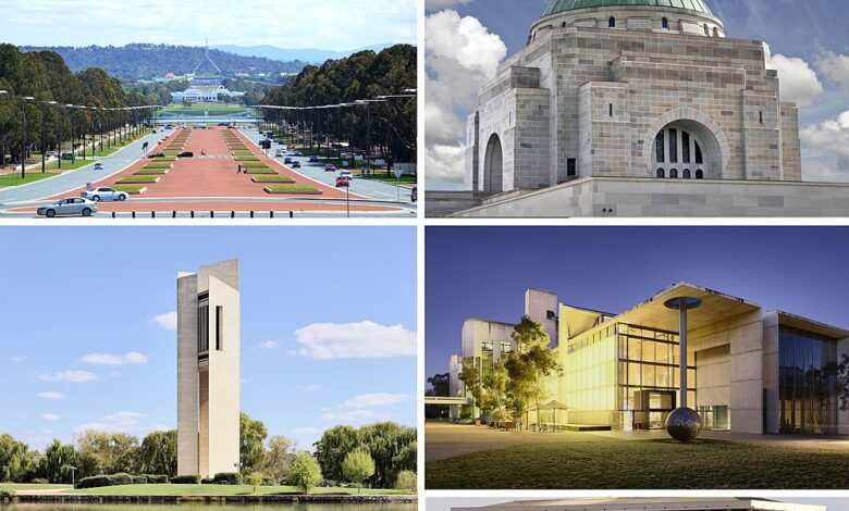
As the seat of the Government of Australia, Canberra is home to many important institutions of the federal government, national monuments and museums. This includes Parliament House, Government House, the High Court and the headquarters of numerous government agencies. It is the location of many social and cultural institutions of national significance such as the Australian War Memorial, the Australian National University, the Royal Australian Mint, the Australian Institute of Sport, the National Gallery, the National Museum and the National Library. The city is home to many important institutions of the Australian Defence Force including the Royal Military College Duntroon and the Australian Defence Force Academy. It hosts all foreign embassies in Australia as well as regional headquarters of many international organisations, not-for-profit groups, lobbying groups and professional associations.
Canberra has been ranked among the world’s best cities to live and visit. Although the Commonwealth Government remains the largest single employer in Canberra, it is no longer the majority employer. Other major industries have developed in the city, including in health care, professional services, education and training, retail, accommodation and food, and construction. Compared to the national averages, the unemployment rate is lower and the average income higher; tertiary education levels are higher, while the population is younger. At the 2016 Census, 32% of Canberra’s inhabitants were reported as having been born overseas.
Canberra’s design is influenced by the garden city movement and incorporates significant areas of natural vegetation. Its design can be viewed from its highest point at the Telstra Tower and the summit of Mount Ainslie. Other notable features include the National Arboretum, born out of the 2003 Canberra bushfires, and Lake Burley Griffin, named for the city’s architects. Highlights in the annual calendar of cultural events include Floriade, the largest flower festival in the Southern Hemisphere, the Enlighten Festival, Skyfire, the National Multicultural Festival and Summernats. Canberra’s main sporting venues are Canberra Stadium and Manuka Oval. The city is served with domestic and international flights at Canberra Airport, while interstate train and coach services depart from Canberra Railway Station and the Jolimont Centre respectively. City Interchange is the main hub of Canberra’s bus and light rail transport network.
Geography
Canberra covers an area of 814.2 km2 (314.4 sq mi) and is located near the Brindabella Ranges (part of the Australian Alps), approximately 150 km (93 mi) inland from Australia’s east coast. It has an elevation of approximately 580 m (1,900 ft) AHD; the highest point is Mount Majura at 888 m (2,913 ft). Other low mountains include Mount Taylor 855 m (2,805 ft), Mount Ainslie 843 m (2,766 ft), Mount Mugga Mugga 812 m (2,664 ft) and Black Mountain 812 m (2,664 ft).
The native forest in the Canberra region was almost wholly eucalypt species and provided a resource for fuel and domestic purposes. By the early 1960s, logging had depleted the eucalypt, and concern about water quality led to the forests being closed. Interest in forestry began in 1915 with trials of a number of species including Pinus radiata on the slopes of Mount Stromlo. Since then, plantations have been expanded, with the benefit of reducing erosion in the Cotter catchment, and the forests are also popular recreation areas.
The urban environs of the city of Canberra straddle the Ginninderra plain, Molonglo plain, the Limestone plain, and the Tuggeranong plain (Isabella’s Plain). The Molonglo River which flows across the Molonglo plain has been dammed to form the national capital’s iconic feature Lake Burley Griffin. The Molonglo then flows into the Murrumbidgee north-west of Canberra, which in turn flows north-west toward the New South Wales town of Yass. The Queanbeyan River joins the Molonglo River at Oaks Estate just within the ACT.
A number of creeks, including Jerrabomberra and Yarralumla Creeks, flow into the Molonglo and Murrumbidgee. Two of these creeks, the Ginninderra and Tuggeranong, have similarly been dammed to form Lakes Ginninderra and Tuggeranong. Until recently the Molonglo River had a history of sometimes calamitous floods; the area was a flood plain prior to the filling of Lake Burley Griffin.
Climate
Under the Köppen-Geiger classification, Canberra has an oceanic climate (Cfb). In January, the warmest month, the average high is approximately 29 °C (84 °F); in July, the coldest month, the average high drops to approximately 12 °C (54 °F).
Frost is common in the winter months. Snow is rare in the CBD (central business district) due to being on the leeward (eastern) side of the range, but the surrounding areas get annual snowfall through winter and often the snow-capped Brindabella Range can be seen from the CBD. The last significant snowfall in the city centre was in 1968. Canberra is often affected by foehn winds, especially in winter and spring, evident by its anomalously warm maxima relative to altitude.
The highest recorded maximum temperature was 44.0 °C (111.2 °F) on 4 January 2020. Winter 2011 was Canberra’s warmest winter on record, approximately 2 °C (4 °F) above the average temperature.
The lowest recorded minimum temperature was −10.0 °C (14.0 °F) on the morning of 11 July 1971. Light snow falls only once or twice per year, and it is usually not widespread and quickly dissipates.
Canberra is protected from the west by the Brindabellas which create a strong rain shadow in Canberra’s valleys. Canberra gets 100.4 clear days annually. Annual rainfall is the third lowest of the capital cities (after Adelaide and Hobart) and is spread fairly evenly over the seasons, with late spring bringing the highest rainfall. Thunderstorms occur mostly between October and April, owing to the effect of summer and the mountains. The area is generally sheltered from a westerly wind, though strong northwesterlies can develop. A cool, vigorous afternoon easterly change, colloquially referred to as a ‘sea-breeze’ or the ‘Braidwood Butcher’, is common during the summer months and often exceeds 40 km/h in the city. Canberra is also less humid than the nearby coastal areas.
Canberra was severely affected by smoke haze during the 2019/2020 bushfires. On 1 January 2020, Canberra had the worst air quality of any major city in the world, with an AQI of 7700 (USAQI 949).
Urban structure
Canberra is a planned city and the inner-city area was originally designed by Walter Burley Griffin, a major 20th-century American architect. Within the central area of the city near Lake Burley Griffin, major roads follow a wheel-and-spoke pattern rather than a grid. Griffin’s proposal had an abundance of geometric patterns, including concentric hexagonal and octagonal streets emanating from several radii. However, the outer areas of the city, built later, are not laid out geometrically.
Lake Burley Griffin was deliberately designed so that the orientation of the components was related to various topographical landmarks in Canberra. The lakes stretch from east to west and divided the city in two; a land axis perpendicular to the central basin stretches from Capital Hill—the eventual location of the new Parliament House on a mound on the southern side—north northeast across the central basin to the northern banks along Anzac Parade to the Australian War Memorial. This was designed so that looking from Capital Hill, the War Memorial stood directly at the foot of Mount Ainslie. At the southwestern end of the land axis was Bimberi Peak, the highest mountain in the ACT, approximately 52 km (32 mi) south west of Canberra.
The straight edge of the circular segment that formed the central basin of Lake Burley Griffin was perpendicular to the land axis and designated the water axis, and it extended northwest towards Black Mountain. A line parallel to the water axis, on the northern side of the city, was designated the municipal axis. The municipal axis became the location of Constitution Avenue, which links City Hill in Civic Centre and both Market Centre and the Defence precinct on Russell Hill. Commonwealth Avenue and Kings Avenue were to run from the southern side from Capital Hill to City Hill and Market Centre on the north respectively, and they formed the western and eastern edges of the central basin. The area enclosed by the three avenues was known as the Parliamentary Triangle, and formed the centrepiece of Griffin’s work.
The Griffins assigned spiritual values to Mount Ainslie, Black Mountain, and Red Hill and originally planned to cover each of these in flowers. That way each hill would be covered with a single, primary colour which represented its spiritual value. This part of their plan never came to fruition, as World War I slowed construction and planning disputes led to Griffin’s dismissal by Prime Minister Billy Hughes after the war ended.
The urban areas of Canberra are organised into a hierarchy of districts, town centres, group centres, local suburbs as well as other industrial areas and villages. There are seven residential districts, each of which is divided into smaller suburbs, and most of which have a town centre which is the focus of commercial and social activities. The districts were settled in the following chronological order:
- Canberra Central, mostly settled in the 1920s and 1930s, with expansion up to the 1960s, 25 suburbs
- Woden Valley, first settled in 1964, 12 suburbs
- Belconnen, first settled in 1966, 27 suburbs (2 not yet developed)
- Weston Creek, settled in 1969, 8 suburbs
- Tuggeranong, settled in 1974, 18 suburbs
- Gungahlin, settled in the early 1990s, 18 suburbs (3 not yet developed)
- Molonglo Valley, development began in 2010, 13 suburbs planned.
The Canberra Central district is substantially based on Walter Burley Griffin’s designs. In 1967 the then National Capital Development Commission adopted the “Y Plan” which laid out future urban development in Canberra around a series of central shopping and commercial area known as the ‘town centres’ linked by freeways, the layout of which roughly resembled the shape of the letter Y, with Tuggeranong at the base of the Y and Belconnen and Gungahlin located at the ends of the arms of the Y.
Development in Canberra has been closely regulated by government, both through planning processes and the use of crown lease terms that have tightly limited the use of parcels of land. Land in the ACT is held on 99-year crown leases from the national government, although most leases are now administered by the Territory government. There have been persistent calls for constraints on development to be liberalised, but also voices in support of planning consistent with the original ‘bush capital’ and ‘urban forest’ ideals that underpin Canberra’s design.
Many of Canberra’s suburbs are named after former Prime Ministers, famous Australians, early settlers, or use Aboriginal words for their title. Street names typically follow a particular theme; for example, the streets of Duffy are named after Australian dams and reservoirs, the streets of Dunlop are named after Australian inventions, inventors and artists and the streets of Page are named after biologists and naturalists. Most diplomatic missions are located in the suburbs of Yarralumla, Deakin and O’Malley. There are three light industrial areas: the suburbs of Fyshwick, Mitchell and Hume.
Sustainability and the environment
The average Canberran was responsible for 13.7 tonnes of greenhouse gases in 2005. In 2012, the ACT Government legislated greenhouse gas targets to reduce its emissions by 40 per cent from 1990 levels by 2020, 80 per cent by 2050, with no net emissions by 2060. The government announced in 2013 a target for 90% of electricity consumed in the ACT to be supplied from renewable sources by 2020, and in 2016 set an ambitious target of 100% by 2020.
In 1996 Canberra became the first city in the world to set a vision of no waste, proposing an ambitious target of 2010 for completion. The strategy aimed to achieve a waste-free society by 2010, through the combined efforts of industry, government and community. By early 2010, it was apparent that though it had reduced waste going to landfill, the ACT initiative’s original 2010 target for absolutely zero landfill waste would be delayed or revised to meet the reality.
Plastic bags made of polyethylene polymer with a thickness of less than 35 µm were banned from retail distribution in the ACT from November 2011. The ban was introduced by the ACT Government in an effort to make Canberra more sustainable.
Of all waste produced in the ACT, 75 per cent is recycled. Average household food waste in the ACT remains above the Australian average, costing an average $641 per household per annum.
Canberra’s annual Floriade festival features a large display of flowers every Spring in Commonwealth Park. The organisers of the event have a strong environmental standpoint, promoting and using green energy, “green catering”, sustainable paper, the conservation and saving of water. The event is also smoke-free.