Zaria

Check Voyage info and Guide for Zaria Here

Check the weather in Zaria Here

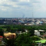
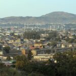
Zaria, situated in the north-central region of Nigeria within Kaduna state, is a city positioned along the Kubanni River, a tributary of the Kaduna River. It functions as the central hub for the Zaria Local Government Council and the traditional Zaria emirate. The city, accessible by road, rail, and a nearby airport to the northwest, comprises distinct areas, including the ancient walled town, Tudun Wada, Sabon Gari, and a township catering to the non-African community.

Historically, Zaria traces its roots back to around 1536 and evolved into the capital of the Hausa state of Zazzau in the late 16th century. Both the town and the state derive their names from Queen Zaria, the younger sister and successor of Queen Amina, the ruler of Zazzau.

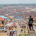
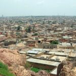
Modern Zaria hosts a diverse population in its different zones, such as the old walled town occupied by Hausa and Fulani residents, and residential areas like Tudun Wada and Sabon Gari established during the colonial era. The old walls, spanning 15 miles (24 km) with eight gates, enclose a vibrant market on an ancient site.

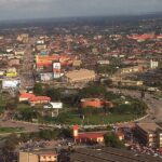
Economically, Zaria plays a significant role as a collection point for various agricultural products like cotton, tobacco, peanuts, shea nuts, hides, and skins. Processing of cotton, peanuts, and shea nuts occurs locally, with the finished products transported by rail to Lagos for export. The city boasts a thriving market for diverse goods, including sorghum, millet, soybeans, brown sugar, onions, locust beans, baobab leaves and fruit, cowpeas, kola nuts, cloth, cattle, sheep, and goats.

The city’s economic activities have diversified over time, encompassing cotton ginning, leather tanning, cotton weaving, dyeing, railway repairing, furniture making, cloth printing, cigarette and cosmetics manufacturing, and basket making. Zaria gained recognition as the birthplace of the first northern Nigerian newspaper in Hausa, “Gaskiya Ta F: Kwabo” (“Truth Is Worth More than a Penny”), launched in 1939.

Zaria stands out as an educational centre in the northern states, hosting Ahmadu Bello University at Samaru, 7 miles (11 km) west-northwest. The university, founded in 1962, includes institutes dedicated to education, economic and social studies, administration, and health. Samaru is also home to the Institute for Agricultural Research and Special Services (established in 1924) and the Leather Research Institute of Nigeria. Additionally, Zaria features the Nigerian Civil Aviation Training Centre, a branch of the Katsina College of Arts, Science, and Technology, a commercial institute, a fine arts school, and a school of pharmacy.

Map view

More from Wikipedia

ID
77151
Name
Zaria
State ID
294
State Code
KD
State Name
Kaduna
Country ID
161
Country Code
NG
Country Name
Nigeria
Latitude
11.11128000
Longitude
7.72270000
WikiData ID
Q147975

Zaria is a metropolitan city in Nigeria which lies within four local government areas in Kaduna State; it is the capital city to the Zazzau Emirate Council, and one of the original seven Hausa city-states and a major city in the state. The local government areas that made up of the city of Zaria includes: Zaria Local Government, Sabon Gari Local Government, Giwa Local Government and Soba Local Government areas in Kaduna state, Nigeria.

It contains Nigeria's largest university, Ahmadu Bello University, and various tertiary institutions including the Federal College of Education(F C E zaria) Nigerian College of Aviation Technology Nigerian Institute of Transport Technology, Nigeria Institute of Leather and Science Technology and Nuhu Bamalli Polytechnic. Nigerian college of Aviation Technology. Department of Agriculture Ahmed Bello University Zaria. Ameer Shehu Idris College of Advanced Diploma.

From the 2006 population census, Zaria was estimated to have 736,000 people. It is home to the Emir of Zazzau.

History

Zaria, initially known as Zazzau, was the capital of the Hausa kingdom of Zazzau. Zazzau is thought to have been founded in or about 1536 and in the late 16th century it was renamed after Queen

  • it was named after Queen Amina sister, Zaria. Human settlement predates the rise of Zazzau, as the region, like some of its neighbors, had a history of sedentary Hausa settlement, with institutional market exchange and farming.

Zaria was the most southern of the Hausa city-states. It was a trading destination for Saharan caravans as well as a prominent city in the Hausa slave trade. In the late 1450s, Islam arrived in Zaria by the way of its sister Habe cities, Kano and Katsina. Along with Islam, trade flourished between the cities as traders brought camel caravans filled with salt in exchange for slaves and grain. The city-state's power peaked under Queen Amina whose military campaigns established a tributary region including the kingdoms of Kano and Katsina. At the end of the 16th century, after Queen Amina's death, Zaria fell under the influence of the Jukun Kingdom and eventually became a tributary state itself. Between the fifteenth and sixteenth century the kingdom became a tributary state of the Songhai Empire. In 1805 it was captured by the Fulani during the Fulani Jihad. British forces led by Frederick Lugard took the city in 1901.

A French hostage of the Islamist group Ansaru, held captive at Zaria, escaped in 2013 and reached a police station in the city.

In December 2015, Nigeria's military was reported to have killed 300 Shia Muslims and buried their bodies in a mass grave. Although the government denies the event, it has been described as a massacre.

Cityscape

The old part of the city, known as Birnin Zazzau or Zaria City, was originally surrounded by walls and fortress, which have been mostly removed. The Emir's palace is in the old city. In the old city and the adjacent Tudun Wada neighbourhood people typically reside in traditional adobe compounds. These two neighborhoods are predominantly occupied by the indigenous Hausa.

There is great variety in the architecture of Zaria, with buildings made of clay in the Hausa style juxtaposed with modern, multi-storied university and government buildings.

Silk-cotton tree is one of the largest trees in Zazzau emirate generally and the tree has played an important role in the spiritual and economic lives of the peoples who live in Zaria especially people of Anguwan Kahu who makes Kahu for the Emirs, district heads, ward heads and village heads. silk-cotton-tree-scientific-name-is-ceiba-pentandra-under-blue-sky.

Anguwan Kahu was known to be a place of business where it use cotton to make local mattresses, pillows, Horse shirts etc.

Wakilin Kahu Zazzau is the head of Anguwan Kahu people and their representative at the emir's palace.

The ward of Anguwan Liman is located north of the Zaria palace.

Gates In Zaria

  1. kofan Doka
  2. Kofan Bai
  3. Kofan Jatau
  4. Kofan Galadima
  5. kofan Gayan
  6. Kofan Kibo
  7. Kofan Kuyambana
  8. Kofan Kona

Transport and economy

Zaria's economy is primarily based on agriculture. Staples are guinea corn and millet. Cash crops include cotton, groundnuts and tobacco. Not only is Zaria a market town for the surrounding area, it is the home of artisans from traditional crafts like leather work, dyeing and cap making, to tinkers, printshops and furniture makers. Zaria is also the center of a textile industry that for over 200 years has made elaborately hand-embroidered robes that are worn by men throughout Nigeria and West Africa.

Because Zaria is north of the rail junction at Kaduna, it has equal rail access to the seaports at Lagos and Port Harcourt. However, only the railway between Lagos and Kano is functional, as the eastern line of Nigeria's rail network is not operational. This means that Zaria currently has rail access to Lagos and Kano to the north but not Port Harcourt.

From 1914 to 1927, Zaria was the break-of-gauge junction station for the Bauchi Light Railway to the tin mines at Jos.

Education

Zaria is home to Ahmadu Bello University, the largest university in Nigeria and the second largest on the African continent. The institution is very prominent in the fields of Agriculture, Science, Finance, Medicine and Law. The school is known for the large number of elites from the region that passed through its academic buildings and counts among its alumni five who were Nigerian heads of state, including the late president Umaru Musa Yar'Adua.

Zaria is also the base for the Nigerian College of Aviation Technology, National Research Institute for Chemical Technology, Nigerian Army Depot, Nigerian Military school, Bassawa Baracks, Federal college of Education Zaria. Some historic secondary schools in the adjoining town of Wusasa, where the former Head of the Federal Military Government Yakubu Gowon resides are the St. Bartholomew's School and Science School Kufena, formerly known as St. Paul's College, also MAISS-GIWA a school established by The Emir of Zazzau Dr. Shehu Idris is situated there. Barewa College (formerly Katsina middle school) and Alhudahuda college are other famous secondary schools in the city.

Traditional festivals

Zaria is among the northern cities that celebrates the annual cultural durbar festivals in Nigeria. The festival is celebrated twice a year which marks the end of Ramadan and also coinciedes the Muslim festivals of eid al adha and eid al fitri respectively. In Zaria the festival is celebrated in phases. The first day, known as Hawan sallah, consists of the eid prayers and the subsequent tour by the emir around the city from the eid ground to his palace in the company of District heads and the royal guards, while the second day known as Hawan Bariki sallah and so the third day known as Hawan Daushe is the for the last tour by the Emir around the city for the festival.

Climate

Zaria has a tropical savanna climate (Köppen climate classification Aw) with warm weather year-round, a wet season lasting from April to September, and a drier season from October to March.

Environment

Air quality

A 2019 study of air pollution in Zaria found that pollution concentrations were within the expected national standards for air pollution.

Land use

Zaria's geography and previous land use meant that much of the city's historical land cover was barren. A 2020 study found that barren land decreased from 1990 to 2020 while built environment increased 66 percent and vegetative land increased by 29%. Vegetation had been decreasing from 1990 to 2005, but the study area found a dramatic increase due to agriculture and reforestation afterwards. Predictive modeling based on local policy and urban development trends suggested that increase in urban and vegetative land cover would continue through 2050.

Water supply and sanitation

Water provided to the city comes from Kaduna State Water Board. As of 2012, the city of Zaria had 30% access to clean water supply. The African Development Fund issued funding for an expansion project in 2013 for 100 million dollars of $480 million. The project had problems with some of its local contractors, resulting in the African Development Bank banning four companies from further participating in bank funding projects. As of August 2020, 60% of water in the system was unaccounted for because of illegal connections, poor metering practices, and poor maintenance.

Notable people

Areas In Zaria

  1. Kwarbai.
  2. Kaura.
  3. Rimin Tsiwa.
  4. Tudun Wada.
  5. magajiya.
  6. Amaru.
  7. Tudun Jukun.
  8. Kusfa.
  9. Rimin Kanbari.
  10. Gyallesu.
  11. Wusasa.
  12. Anguwan Dankali.
  13. Jushi.
  14. Banzazzau.
  15. Nagoyi.
  16. Anguwan Juma.
  17. Anguwan iya.
  18. Limancin Kona.
  19. Limancin Iya.
  20. Salmandona.
  21. Albarkawa.
  22. Madaka.
  23. Anguwan Fatika.
  24. Anguwan Kaya.
  25. Filin Mallawa.
  26. Kofan Doka.
  27. Kofan Kona.
  28. Kofan Galadima.
  29. Tukur Tukur.
  30. Anguwan Dankali.
  31. Rimin Kanbari.
  32. Rimin Kwakwa.
  33. Rimin Danza.

Administrative Subdivisions

  1. Kwarbai A Ward.
  2. Kwarbai B Ward.
  3. Kaura Ward.
  4. Limanci Ward.
  5. Anguwan Fatika Ward.
  6. Tudun Wada Ward.
  7. Tukur Tukur Ward.
  8. Kufena Ward.
  9. Dutsen Abba Ward.
  10. Gyallesu Ward.
  11. Dambo Ward.
  12. Wucicciri Ward.

See also

Bibliography

  • Smith, Michael G. (1960) Government in Zazzau 1800–1950 International African Institute by the Oxford University Press, London, OCLC 293592; reprinted in 1964 and 1970.
  • Dan Isaacs (28 September 2010). "Nigeria's emirs: Power behind the throne". BBC News. Retrieved 29 September 2010.

References

External links

Media related to Zaria at Wikimedia Commons Zaria travel guide from Wikivoyage

References


Discover


Powered by GetYourGuide

Subscribe to our Newsletter

Leave a Reply

Your email address will not be published. Required fields are marked *

Adblock Detected

Hello, Our system has detected that you are using Adblocker while acessing this website. Kindly disable it to support us.