Alou
Alou is a town and commune in the South-West region of Cameroon. The Alou sub-division constitue one of the three sub-divisions (Alou, Wabane and Fontem) in the Lebialen division. This town/viallage got its name from the foggy nature of the climate, especially during the raining season. Alou in the Nweh language means “Fog”.
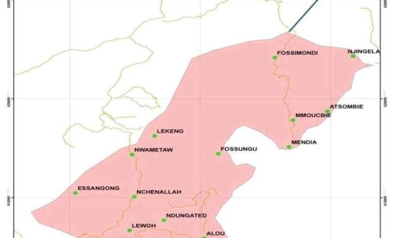
Besides Alou itself, the urban area of Alou is divided into several districts such as Emollah, Kongho, Nwametaw, Njenafey, Njenallah and Ndungated etc. Far from the urban area, the rural area of the municipality of Alou contains seven villages:
- Attraction
- Fonjometaw
- Lewoh
- M’mouck
- M’mouckbie
- Ndungated
- Nwangong
Geography
Location
Alou council is geographically located at eastern coordinate of 5312890 and western of 9562480 at an elevation of 1611m above sea level. It is circumscribed in Alou Sub Division in Lebialem Division of the South Region in Cameroon. It is bounded in the North by Wabane Sub Division and in the South by Fontem Sub Division. It further shares a common boundary to its West by Menoua Division (West region) and to the East by Manyu Division of the South West Region.
The creation of Alou Sub Division by Decree no 94/010 on January 12, 1994, paved a way for a constituted people of Alou Sub Division to benefit the status of a rural council legalized by decree no 95 / 085 of 24th April 1995.
Its urban space covers 14 villages which are in two main Fondoms of Ndungatet and Nwametaw. The Ndungatet Fondom of the urban space stretches from the Foto’s Palace through Sandsan quarter, Three-corners, Atululi to the main market while the Nwametaw end of the urban space starts from the its Palace across Nwasah village, Nchenallah Nqwuin villages towards the main market.
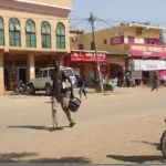
The urban space host the central administration of Alou Sub Division, the council premises, administrative structures, a main market and significant population of villagers and civil society.

Climate
The council area experiences a bi-modal climate (2 seasons) regime – the dry season and the rainy season. The dry season begins in November and ends in March while the rainy season that begins in mid-march and stretches up to October and sometimes November. Average annual rainfall varies from 1400mm to 1800mm. However, these seasons are gradually becoming unpredictable owing to the phenomenon of climate change.
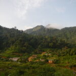
The majority of the areas within the municipality is generally cold to very cold especially in the evening which is accompanied by dense fog locally called “Aluo”. Temperatures vary between 180C to 300C, though sometimes it can go below the 180C especially during the harmattan periods of November to January. It is widely known that the name Alou is derived from the foggy nature of the area. The coldness is due to the altitude that ranges from 1611m around 3-corners Ndungated to 1900m in Mbelenka (M’muockngie).
The soil
The soils in Alou vary due to the difference in topography and vegetation. From the lower part of Effong, Njenawung, through Ndung nwa and parts of M’mouckbie the soils are reddish, rocky and gravely with a thin organic matter layer (5-10cm). The top soil horizons emanate from the underlying sedimentary rocks and metamorphic rocks which have surfaced around the black-stone quarry in Nchenallah and Atululi (stone-head) areas of the urban space.
The presence of many eucalyptus trees render the soil to be poor due to many ramified tree plant rooting in the soil. This notwithstanding, results of a soil analysis carried out by the Institute of Agricultural Research for Development (IRAD) Ekona between M’mouckmbie to M’mouckngie in 2010 showed that the soils within these zones are comparatively deeper upper layer, slightly acidic (pH 4.87-6.64), higher in nitrogen and a CEC of less than 10cmol. These soils support the cultivation of vegetable crops including irish potato, cabbage, carrots and leeks. However, due to the topography of the land and the silty to sandy texture of the soil, these soils are susceptible to leaching and soil erosion. This must be controlled in order to sustain the relief and Landforms.
In general, the land form in the Alou municipality is hilly and undulating particularly in the South West of the area.. It gradually rises from an altitude of 450m at Ndumbin through 1611m at Ndungatet and Nwametaw (in the urban space) to over 2100m in Mbelenka. Though some of the hill tops are broad-shaped, many are characterised by truncated Vshaped valleys with small streams or rivers.
Hydrology
There are 02 main rivers – RiversNtsembou that croses below and forms the natural boundary between Alou and Alou municipalities, Belarack in Ndumbin, Ntzeh-To between Lewoh and Njenawung, Ntzeh-Mbup, Ngemamoh and Ntzeh-Choh – all crossing through Njenawung flows flows down to join River Bagwor in Upper Bayang Sub-Division. There are equally many small streams that cut through the villages in the lower parts of M’mouckmbie down to Njenawung to Ndumbin. The majority of the villages get drinking water from small streams and springs. A few villages are however, provided with pipe-borne water.
Vegetation (Flora) and Wildlife (Fauna)
Vegetation (Flora).
The area has two main vegetations, the typical ever green forest which covers the lower zones of Nkandu, Njenatah, Efong, Atem, Alou, Keleng, Attrah etc. These villages show a spatial view of mainly palm trees interspaced by cocoa farmland and a few tall forest trees and shrubs (timber and non-timber forest products). The forest area changes sharply to a typical tropical savanna vegetation from Anya Menkey Atullah, Nembat villages of Upper lewoh zone, M’mockmbie and M’muockngie, areas with conspicuous clusters of Eucalyptus trees and shrubs.
Fauna (Wildlife)
The difference in vegetation type gives rise to a variety of wildlife species. Wildlife in the lower forest zones are mainly monkeys (Cercopithecus spp) Porcupine(Atherurus africanus) and antelopes while in the upper savanna zones they are cane rats (Thryonomys swinderianus) and rat moles. They are equally a variety of reptiles, birds and insect species in both types of vegetation.
Economic activities
The council area experiences limited economic diversity, primarily relying on agriculture as its main source of income. The majority of its residents are engaged in farming, earning an average monthly income of 30,000 FCFA (SDDARD Alou). The M’muock zone stands out as a hub for intense farming activities, where heavy trucks are a common sight, transporting various vegetable crops like Irish potatoes, cabbage, carrots, and leeks to neighboring cities such as Dschang, Douala, and Kumba.
Aside from agriculture, the inhabitants are also involved in off-licence sales, running restaurants, and engaging in small-scale trade, particularly in provision stores. These provision stores are typically situated around the permanent markets, with many of the store owners residing in other villages and operating their businesses primarily on market days.
Furthermore, economic groups like builders (including carpenters and bricklayers), auto mechanics, and tailors play an active role in the villages, contributing to the local economy with an average monthly income of about 10,000 FCFA.